
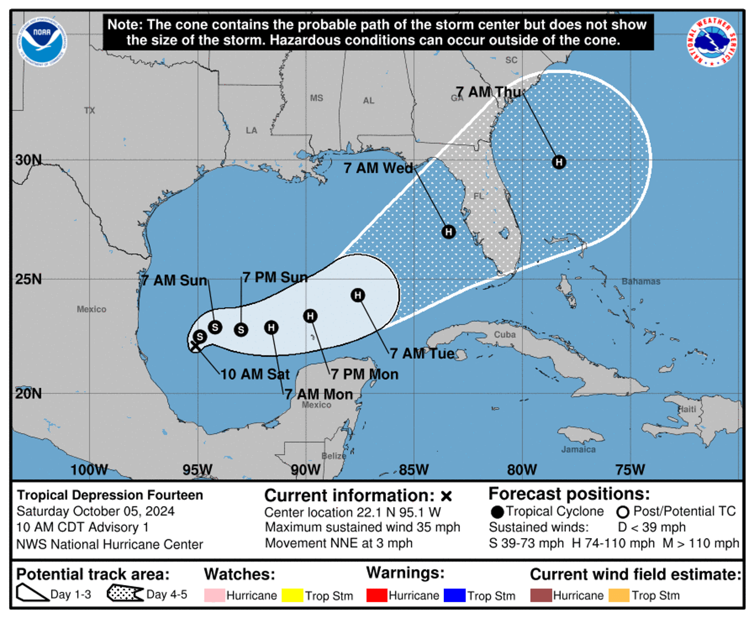
Tropical Storm Milton is likely to become a major hurricane in three days as it aims for Florida’s already storm-battered west coast, federal forecasters said Saturday.
The National Hurricane Center said in a forecast discussion the storm was rapidly evolving into “an intense hurricane with multiple life-threatening hazards” for the coastline north and south of the Tampa Bay region.
The center’s forecasters said Milton was likely to reach hurricane status — defined by sustained winds of at 74 mph — in 36 hours, followed by major hurricane status — a Category 3 defined by sustained winds of at least 111 mph — in 72 hours.
On Saturday, Gov. Ron DeSantis preemptively declared a state of emergency for 35 counties, including the Tampa Bay peninsula of Pinellas County, still recovering from Hurricane Helene.
The governor’s declaration cited possible “life-threatening storm surge and wind impacts” for the state’s west coast starting as soon as Tuesday evening and continuing Wednesday.
Milton’s explosive growth from tropical depression to tropical storm in the Gulf of Mexico in a matter of hours Saturday presents the storm as yet another potential disaster for the Southeast.
It comes less than 10 says after Helene made landfall along Florida’s Big Bend region on Sept. 26 and made its way toward Tennessee and North Carolina, where it caused devastating flooding.
In Florida, Helene whipped up waves and pushed the Gulf of Mexico 8 feet onto otherwise dry land occupied by homes, apartments, mobile homes, restaurants, bars and shops on Sept. 26, killing 12 in Pinellas County and 25 statewide. At least 230 people across six states died as a result of the storm.
Storm’s path is rare
Milton is fueled by unusually warm water in the Gulf of Mexico, where one National Oceanic and Atmospheric Administration-tracked buoy near the storm’s projected path Saturday night recorded a water temperature of nearly 86 degrees, 2 degrees warmer than the air. The storm is already being noted for rare attributes during a busy Atlantic hurricane season.
It will be the fifth hurricane to make landfall on the U.S. mainland in 2024, tying 2004, 2005, and 1893 for the most hurricanes to make mainland landfall on record.
And it’s a rarified product of its development in the Bay of Campeche, a sheltered southern bite in the Gulf of Mexico west of the Yucatán Peninsula. Since 1850, only two storms born there have struck Florida; none have done it in the past 155 years, with the last to take that path recorded in 1867.
Milton is the sixth named storm of the Atlantic hurricane season, which now has recorded the most such storms between Sept. 24 and Oct. 5, according to Colorado State University meteorologist Philip Klotzbach.
The last time three named storms (including Kirk and Leslie) were spinning in the Atlantic in October was 2018, he said.
Heavy rain possible ahead of storm
As of 5 p.m. ET, Milton was 245 miles north of Veracruz, Mexico, and was pushing out maximum sustained winds estimated to be 40 mph, with some higher gusts, the hurricane center said. It was moving north-northeast at 3 mph, it said.
The hurricane center’s latest forecast cone has Milton reaching major hurricane status early Tuesday afternoon and reaching the Pinellas County coastline early Wednesday afternoon.
The cone has some uncertainty built in, with past forecasts off an average of 150 miles when they’re projecting a storm’s behavior four days before landfall, the hurricane center said.
“Regardless of where the track goes, it’s going to produce heavy rain,” National Hurricane Center Deputy Director Jamie Rhome said in a video update Saturday.
Hurricane and storm surge watches will likely be required for certain regions of Florida on Sunday, many of which have just been hard-hit by Helene. The center said areas of heavy rainfall will impact portions of the state on Sunday and Monday, well ahead of the tropical system’s arrival, heightening the risk of flooding.
Rain from outer bands of the storm could begin for Florida’s west coast Sunday, federal forecasters said, with heavier rain likely to move in Tuesday and Wednesday and bring with it the possibility of flash flooding and moderate river flooding.
Residents urged to prepare
The system may produce rainfall of two to four inches across portions of the northern Yucatán Peninsula and western Cuba as well.
The hurricane center is warning those in these areas, as well as in the Florida Peninsula, the Florida Keys, and the Bahamas, to closely monitor this system for any potential impacts.
Residents of the Tampa Bay region and beyond should prepare, the National Hurricane Center said in its forecast discussion.
“Residents in these areas should ensure they have their hurricane plan in place, follow any advice given by local officials, and check back for updates to the forecast,” it said.
Pinellas County is making sandbags available to its residents. The National Weather Service placed the region in the potential path of Tropical Storm Milton, although it is still too early to tell how the storm will impact the county.
Rhome, of the hurricane center, said residents of the state’s west coast should ensure they have several days’ food and water on hand, and that vehicles are topped off with fuel and cellphones are charged. They should also have necessary prescription medicine to last a week or two, and have sufficient cash on hand in the event credit, debit and digital payment systems are down.


